Spatial epidemiology of Viral Hemorrhagic Fevers
Updated October 11, 2017
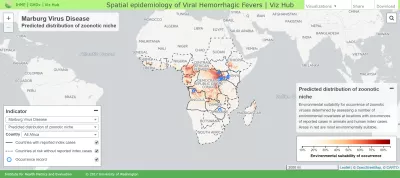
With this interactive mapping tool, explore local assessments of where in Africa specific infectious diseases (Ebola virus disease, Marburg virus disease, Lassa fever, and Crimean-Congo hemorrhagic fever) have the greatest potential to emerge and subsequently spread. Examine national and subnational variation in where outbreaks could begin, spread locally, or progress into a widespread epidemic impacting communities across the region and internationally. Compare diseases’ pandemic potential assessments with recorded occurrences. View outputs and share map settings easily.
Please note that this tool builds upon and replaces the “Spatial epidemiology of Ebola virus disease” visualization.
Citation
Institute for Health Metrics and Evaluation (IHME). Spatial epidemiology of Viral Hemorrhagic Fevers disease visualization. Seattle, WA: IHME, University of Washington, 2017. Available from http://vizhub.healthdata.org/lbd/pandemics. (Accessed [INSERT DATE])
Browser notes
- Use the latest version of Chrome, Edge, Safari, or Firefox.
- Use Ctrl+0 to reset the browser zoom. Sometimes having the browser zoomed in or out interferes with the layout or a few mouse-dependent properties.
- If the visualization isn't loading or looks distorted, try clearing your cache. See http://www.wikihow.com/Clear-Your-Browser's-Cache for pointers.